
Scientific research point to future threat of earthquakes across Himalayan belt including Nagaland
Naga Republic News
Given that Nagaland is considered a ‘very high risk state’, can a city like Kohima survive a major earthquake?
Although earthquakes cannot be accurately predicted, the future threat across the Himalayan belt including Nagaland has been forewarned through scientific explanation and past trends.
A report in the Down to Earth magazine dated 13 July 2016 mentions about a new paper published in journal Nature Geoscience warning of a potentially devastating earthquake ripping through the densely populated Bangladesh as well as hill towns of North-East India.
The paper has analysed GPS measurements to prove that the Indian tectonic plate is thrusting under the Eurasian plate even under Bangladesh, causing stress to build up along the convergence for at least the last 400 years. If this stress were to rupture in a single event, it could cause an earthquake of 8.2 to 9 magnitude on the Richter scale.
The findings revealed that eastern India is moving diagonally towards Myanmar at 46 mm per year. While most of the strain of this movement is absorbed by surrounding faults, 17 mm of the movement is bringing Bangladesh and Myanmar closer, causing the landscape to appear like “a carpet being shoved against a wall”.
Nagaland with the rest of the Northeastern states falls under earthquake zone –v, making it a very high risk state, according to information provided by the Nagaland State Disaster Management Authority (NSDMA).
On top of this it is explained that “with all young, weak rocks and the rugged topography, the greater part of Nagaland is prone to landslides”.
Geologically it is informed that Nagaland forms a part of the northern extension of the Arakan-Yoma Range representing some of the Cretaceous and Tertiary orogenic upheavals forming a fairly young and mobile belt of the earth.
Accordingly, rock falls are also common. Above this, many towns and villages including the capital city Kohima lies above the Disang basement. This makes it more vulnerable. The NSDMA mentions that the Disang basement is made up of weak rocks and cover greater part of Nagaland.
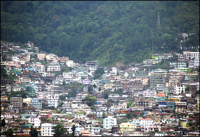
Another Vulnerability of Nagaland is the increased concentration of population in hazardous environments. This is also another cause of concern because many people are still unaware of the dangers of concentrating in hazardous areas.
More worrisome is that most of the structures in Nagaland, both Government and Private have been constructed without proper planning and expert consultancy. Above that, land use planning has never been a point for consideration for all types of developmental activities, states the NSDMA.
According to Home Commissioner Abhishek Singh, who heads the NSDMA, experts from National Disaster Management Authority estimate that if an Earthquake of intensity 8.7 occurs in Nagaland – similar to the Great Shillong earthquake of 1897 or the Assam Earthquake of 1950 – almost 30000 lives will be lost and around 180000 people will sustain injuries.
“These numbers may actually go up given the unplanned construction and high rise buildings constructed in Kohima Town and other urban habitations”, says the NSDMA official.

Meanwhile in an article in Science, published a few years ago in response to the 2001 Bhuj earthquake in India, calculated that 70 percent of the Himalayas could experience an extremely powerful earthquake.
The prediction came from research of the historical records from the area as well as the presumption that since the 1950 Assam-Tibet earthquake, enough slippage has taken place for a large earthquake to occur.
Not surprisingly, in 2015, the Himalayas were hit by another large earthquake with an epicenter further west in Nepal. Nearly 9,000 people were killed and 22,000 injured. It was the worst natural disaster to strike Nepal since the 1934 Nepal–Bihar earthquake.
The Himalayan range stretches 2,500 km from Afghanistan to Myanmar. As mentioned in scientific studies, an earthquake of a powerful magnitude was imminent in the highly seismic Himalayan zone, where Nepal is situated.
North-East India has also had its share of earthquakes from mild, to moderate and to devastating ones.
The Shillong earthquake of 1897 with 8.7 magnitude is the largest known Indian intraplate earthquake. It raised the northern edge of the Shillong Plateau by more than 10 m, resulting in the destruction of structures over much of the plateau and surrounding areas and causing widespread liquefaction and flooding in the Brahmaputra and Sylhet floodplains.
The 1950 Assam–Tibet earthquake, also known as the Assam earthquake or Medog earthquake occurred on August 15, and had a magnitude of 8.6. The epicenter was located near Rima, Tibet. The earthquake was destructive in both Assam and Tibet, and approximately 4,800 people were killed.
The earthquake is notable as being the largest recorded quake caused by continental collision rather than subduction, and is also notable for the loud noises produced by the quake and reported throughout the region.
The NSDMA in its official records mentions about interviews done with the older generation people revealing that the 1950 earthquake was very much felt by Nagaland, and it even resulted in the destruction of many houses in certain areas. It was even said that the earth opened up and buffalos were buried alive.
The 2011 Sikkim earthquake (also known as the 2011 Himalayan earthquake) was of lesser magnitude of 6.9 but it was still felt across northeastern India, Nepal, Bhutan, Bangladesh and southern Tibet. At least 111 people were killed in the earthquake.
Given the threat perception of an impending earthquake in the North-East region, the National Disaster Management Authority (NDMA) is reportedly conducting multi-State mock drill exercise on earthquake disaster simultaneously in all districts of Nagaland, Manipur, Tripura and Mizoram involving all stakeholders.
It was informed that these Mock exercises to be held on April 26 will be staged from the Scenario of Shillong Earthquake of 1897. Interestingly, the major earthquakes in the region (Shilong-1897, Assam-1950 and Nepal-2015) all struck during the summer season.
“Nagaland State Disaster Management Authority (NSDMA) will be organising Mock Exercises for preparedness for Disaster Management on 26th April along with other States in the country”, confirmed Home Commissioner, Abhishek Singh in his social media communiqué pointing out that it was important for all stakeholders to be aware of the risks that we have and what all we can do to save lives if an Earthquake of high intensity occurs.
Ahead of state wide mega mock drill of Nagaland emergency preparedness exercise on April 26, the Nagaland State Disaster Management Authority held a day-long review meeting at ATI on 12th April 2018. The program was organized by Home department in collaboration with NDMA Government of India.
While delivering the keynote address, the Home Commissioner suggested that short videos on prevention of earthquakes, fire, flood etc. should be created and shared on channels like youtube and whatsapp. Pointing out the vital role played by the media to connect with citizens, he hoped that the mock drill which will be conducted on the 26th April 2018 will be a success in preventing future disasters.
Related post Safety tips and preparedness for disaster management


 What Does Your Face Say About Your Health?
 The Top Viral YouTube Videos of 2017
 Meet R.N. Ravi, who is mediating peace with the Nagas
 An orbiting message of peace


Leave a Reply
Your email address will not be published. Required fields are marked (required)